
Aerial Photography and Video from RC Aircraft
Aerial Still Photography 2004 2005 2006 2007 2008 2009 2010 2011 2012 2013
This section shows the cameras I have used for aerial photography and the electronics I have made to remotely trigger the shutters on still digital cameras. The price you can pay for a digital camera runs from $11 to hundreds of $. There are a few examples of those photos shown at the top of this page to whet your appetite, with links to many more of the aerial photos I have taken at various spots around the world.
There are two main ways to trip the shutter on a camera; electronically and with a servo. The electronic path with a digital switch is much cleaner in setup, plus no extra weight is required for the servo. The best switch setup I have found is the CamMan, and I have installed it in several cameras. I also have a custom switch very similar to the CamMan using the same programmable integrated circuit (PIC), a 12C508. My source code and executable for that PIC switch is available for free on this webpage. I cover all the cameras I have used or hacked, with tips on their use and detailed photos of exactly where to solder and where to get the software you will need.
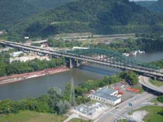 Charleston, West Virginia |
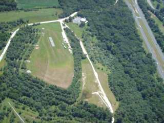 RCMB, Maryland |
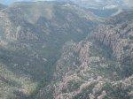
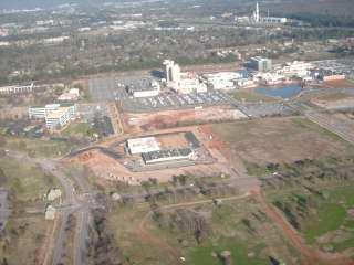 Huntsville, Alabama |
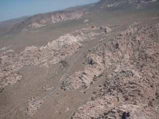 Joshua Tree, California |
 Yuma, Arizona |
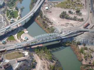
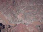 Grand Canyon, Arizona |
 Chiricahua, Arizona |
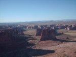 Arches, Utah |
 Canyonlands, Utah |
 Juccasjarvi, Sweden |
|
Aerial videos
2010
2011
2012
2013
2014
2015
2016
2017
2018
2019
Sweden-Norway 2019
Utah 2019
2020
2021
2022
2023 |
|
|
This section has links to aerial videos I have shot all over the world with various video cameras in my RC planes. Starting in 2016, some of these videos were flown with first person view (FPV) equipment on 5.8 Ghz. The video cameras themselves are shown below when I started using that camera. |
|

 Sony Bloggie - two versions |
|
|
|
|
|
Sony Bloggie HD aerial video, 2010 |
|
|
RCMB
Flying Field, Maryland, 10 November 2010 RCMB Flying Field, Maryland, 13 November 2010 |
Location in Google Maps Location in Google Maps |
|
Sony Bloggie HD aerial video, 2011 |
|
| Lake Havasu, Arizona, 22 January 2011 | Location in Google Maps |
| Joshua Tree National Park, 23 January 2011 | Location in Google Maps |
| Yuma, Arizona, 11 April 2011 | Location in Google Maps |
| Vidsel, Sweden, 28 June 2011 | Location in Google Maps |
|
Sony Bloggie HD aerial video, 2012 |
|
| Canyonlands National Park, Needles District, Utah, 03 November 2012 | Location in Google Maps |

 GoPro Hero 3 Turnigy 2K HD-Cam / SJ4000 GoPro Hero 3 HD aerial video, 2014 |
|
|
RCMB Flying Field, Maryland, 23 February 2014 RCMB Flying Field, Maryland, 17 August 2014 West of Castle Dome Peak, Kofa NWR, AZ, 21 November 2014 (2 flights) West of Castle Dome Peak, Kofa NWR, AZ, 22 November 2014 (2 flights) |
Location in Google Maps Location in Google Maps Location in Google Maps Location in Google Maps |
GoPro Hero 3 HD aerial video, 2015 |
|
|
Martinez Lake from west side of Colorado River,
north of Yuma, Arizona, 07 February 2015 Confluence of Colorado River and Gila River, Yuma, Arizona, 08 February 2015 West of Castle Dome Peak, Kofa NWR, Arizona, 09 February 2015 Martinez Lake from east side of Colorado River, north of Yuma Arizona, 10 February 2015 Valley Of The Gods, Utah, 16 February 2015 (2 flights) RCMB Flying Field, Maryland, 29 March 2015 McPhaul Bridge over Gila River, Yuma, Arizona, 13 April 2015 Mittry Lake, Yuma, Arizona, 14 April 2015 & 23 April 2015 Adair Road RC Flying Field, Yuma, Arizona, 16 April 2015 & 21 April 2015 Palm Canyon, Kofa NWR, Arizona, 19 April 2015 Lake Havasu, Arizona, 19 April 2015 Confluence of Colorado River and Gila River, Yuma, Arizona, 22 April 2015 & 16 May 2015 Picacho State Recreation Area, California, 17 May 2015 (2 flights) West of Castle Dome Peak, Kofa NWR, Arizona, 18 May 2015 Fortuna Foothills, Yuma, Arizona, 19 May 2015 Fortuna Foothills, Yuma, Arizona, 04 & 08 June 2015 Castle Dome Peak, Kofa NWR, Arizona, 05 June 2015 Lake Havasu, Arizona, 06 June 2015 Senator Wash Slot Canyon, California, 07 June 2015 Ferguson Lake, California, 07 June 2015 (2 flights) The Slot, Anza-Borrego Desert State Park, California, 14 June 2015 Summersville Lake, West Virginia, 05 September 2015 RCMB Flying Field + RCMB Fall Picnic, 19 September 2015 Dinosaur National Monument, Utah, 17 October 2105 South of Mountain View, Wyoming, 18 October 2015 West of Kanab, Utah, 23 October 2015 Coral Pink Sand Dunes State Park, Utah, 23 October 2015 RCMB Flying Field, Maryland, 08 November 2015 |
Location in Google Maps |
|
GoPro Hero 3 HD aerial video, 2016 |
|
|
Ohio River, West Virginia, 26 March 2016 (2
flights) RCMB Flying Field, Maryland, 17 April 2016 (2 flights) Petersburg Battlefield National Historic Park, Five Forks, Virginia (2 flights) Earls, Virginia, 9 & 10 May 2016 RCMB Flying Field, Maryland, 28 May 2016 Senator Wash Slot Canyon, California, 15 August 2016 (FPV) Adair Road Flying Field, Yuma, Arizona, 27 August 2016 (FPV) Kofa Range, Arizona, 29 August 2016 (FPV) |
Location in Google Maps - flight #1,
flight #2 Location in Google Maps Location in Google Maps - flight #1, flight #2 Location in Google Maps Location in Google Maps Location in Google Maps Location in Google Maps Location in Google Maps |
|
Turnigy 2K HD-Cam (SJ4000) HD aerial video, 2016 |
|
|
RCMB Flying Field, Maryland, 25 June 2016 The Slot, Anza-Borrego State Park, California, 14 August 2016 (2 flights) Pacific Crest Trail, Laguna Mountains, California, 14 August 2016 Ferguson Lake, California, 15 August 2016 Yuma, Foothills, Arizona, 16 & 29 August 2016 Colorado & Gila Rivers Confluence, Yuma, Arizona, 16 August 2016 Dry Fork Slot, Grand Staircase - Escalante NM, Utah Hole In The Rock, Grand Staircase - Escalante NM, Utah Mexican Hat, Utah, 22 August 2016 Sedona, Arizona, Schnebly Hill Road, 22 August 2016 Martinez Lake, Arizona, 27 August 2016 McPhaul Bridge, Gila River, Yuma, Arizona, 27 August & 7 September 2016 Yuma Territorial Prison, Arizona, 28 August 2016 Mittry Lake, Yuma, Arizona, 31 August 2016 (2 flights) Lake Havasu, Arizona, sunset, 3 & 4 September 2016 Mill Canyon Spring Road near Mt Timpanogos, Utah, 18 September 2016 Kane Springs Creek Canyon, Moab, Utah, 29 September 2016 Corona Arch Trailhead, Moab, Utah, 29 September 2016 |
Location in Google Maps Location in Google Maps - flight #1, flight #2 Location in Google Maps Location in Google Maps Location in Google Maps Location in Google Maps Location in Google Maps Location in Google Maps Location in Google Maps Location in Google Maps Location in Google Maps Location in Google Maps - 27 August, 7 September Location in Google Maps Location in Google Maps - flight #1, flight #2 Location in Google Maps Location in Google Maps Location in Google Maps Location in Google Maps |
|
GoPro Hero 3, aerial video, 2017 |
|
| The Narrows Slot Canyons, Picacho SRA, California, 01 March 2017 | Location in Google Maps |
| Adair Road Flying Field, Yuma, Arizona, 02 March 2017 | Location in Google Maps |
| Castle Dome Peak, Kofa NWR, Arizona, 04 March 2017 (2 flights) | Location in Google Maps |
| Foothills, Yuma, Arizona, 06 & 13 March 2017 | Location in Google Maps |
| Senator Wash Slot Canyon & Ferguson Lake, California, 07 March 2017 (2 flights) | Location in Google Maps - flight #1, flight #2 |
| Colorado & Gila River Confluence, Yuma, Arizona, 08 March 2017 | Location in Google Maps |
| Lake Havasu, Arizona, 12 March 2017 (4 flights) | Location in Google Maps - flights #1 to #3, flight #4 |
| Buttercup Dunes, Imperial Sand Dunes Recreation Area, California, 13 & 14 March 2017 (8 flights) | Location in Google Maps |


 Eachine VR-D2 Pro Googles EV200D Googles Gear 360 Runcam Split 2 Runcam Split Mini AKKTek Infinite DVR |
|
|
HD-DVR / Recorded from downlink on Eachine VR-D2 goggles, aerial video, 2017 |
|
| Downlinked video from flying wing with EagleTree system, setup #1, RCMB, 01 October 2017 | Location in Google Maps |
| Eachine Racer 250 with HD-DVR from V-Tail 210, around my front yard, 14 October 2017 | |
| Eachine Racer 250 with HD-DVR from V-Tail 210, RCMB, 15 October 2017 | Location in Google Maps |
| Eachine Racer 250 with HD-DVR from V-Tail 210, RCMB, 22 October 2017 | Location in Google Maps |
| Downlinked video from flying wing with EagleTree system, setup #2, RCMB, 22 October 2017 | Location in Google Maps |
|
Gear 360 / SJ4000 / Cyclops DVR / Runcam Split Mini, aerial video, 2018 |
|
| First flight on 180-sized quadcopter, my front yard, 01 May 2018 - Runcam Split Mini (FPV) | |
| RCMB Flying Field, Maryland, 20 April 2018 - Gear 360 | Location in Google Maps |
|
Utah, Summer 2018: |
|
| White House Campground, east of Kanab, Utah - Cyclops Camera/DVR | Location in Google Maps |
| The Wedge Overlook, Utah - Cyclops Camera/DVR | Location in Google Maps |
| San Rafael River Bridge, Buckhorn Draw Road, Utah - Cyclops Camera/DVR | Location in Google Maps |
| San Rafael River Bridge, Buckhorn Draw Road, Utah - SJ4000 Camera | Location in Google Maps |
| San Rafael Reef, north of Goblin Valley, Utah - SJ4000 Camera (2 flights) | Location in Google Maps |
| Little Wildhorse Canyon Trailhead, west of Goblin Valley, Utah - Cyclops Camera/DVR | Location in Google Maps |
| Skull Valley, Utah - SJ4000 Camera | Location in Google Maps |
| Simpson Springs Pony Express Station - Runcam Split Mini | Location in Google Maps |
| Simpson Springs Pony Express Station & Lookout Pass, Utah - Cyclops Camera/DVR | Location in Google Maps - flight #1, flight #2 |
| Lookout Pass, Utah - SJ4000 Camera | Location in Google Maps |
| Brian Head Peak, Utah - Cyclops Camera/DVR | Location in Google Maps |
| Kolob Reservoir, west of Zion National Park - SJ4000 Camera | Location in Google Maps |
| White House Campground, east of Kanab, Utah - SJ4000 Camera | Location in Google Maps |
| White House Campground, east of Kanab, Utah - Runcam Split Mini | Location in Google Maps |
| Grosvenor Arch, Utah - Runcam Split Mini | Location in Google Maps |
| Escalante River Gorge, Utah - SJ4000 Camera | Location in Google Maps |
| Fortymile Ridge Road, Utah - SJ4000 Camera (2 flights) | Location in Google Maps |
|
Comparison of Gear 360, Runcam Split Mini, SJ4000, and Cyclops all on 26 August 2018 at RCMB: |
|
| RCMB Flying Field, Maryland, 26 August 2018 - Gear 360 | Location in Google Maps |
| RCMB Flying Field, Maryland, 26 August 2018 - Runcam Split Mini | Location in Google Maps |
| RCMB Flying Field, Maryland, 26 August 2018 - SJ4000 | Location in Google Maps |
|
RCMB Flying
Field, Maryland, 26 August 2018 - Cyclops Camera/DVR |
Location in Google Maps |
| RCMB Flying Field, Maryland, 28 August 2018 - Runcam Split Mini - beginner aerobatics | Location in Google Maps |
| RCMB Flying Field, Maryland, 28 August 2018 - Cyclops - low level flying | Location in Google Maps |
| RCMB Flying Field, Maryland, 01 Sep 2018 - Runcam Split Mini - beginner aerobatics | Location in Google Maps |
| RCMB Flying Field, Maryland, 02 Sep 2018 - Runcam Split Mini - beginner aerobatics | Location in Google Maps |
| RCMB Flying Field, Maryland, 03 Sep 2018 - Runcam Split Mini - air-to-air | Location in Google Maps |
| RCMB Flying Field, Maryland, 02 & 03 Sep 2018 - SJ4000 - low level flying | Location in Google Maps |
| RCMB Flying Field, Maryland, 07 Sep 2018 - Runcam Split Mini - beginner aerobatics | Location in Google Maps |
| RCMB Flying Field, Maryland, 22 Sep 2018 - Gear 360 - low level flying | Location in Google Maps |
| RCMB Flying Field, Maryland, 22 Nov 2018 - SJ4000 - low level flying | Location in Google Maps |
| RCMB Flying Field, Maryland, 25 Nov 2018 - HD-Cam, Cyclops, SJ4000 comparison | Location in Google Maps |
|
I have applied the
Deshaker stabilizer filter to some airborne videos to
smooth them out. Deshaker is a plug-in for the
video editing software
VirtualDub.
Deshaker does a great job removing the aircraft
motions and bumpy air disturbances as a plane moves. Best of all,
both VirtualDub and Deshaker are free. There are
many examples of 'deshakered' aerial videos
highlighted in yellow
below; the different settings are
explained with each video on its YouTube page. I
also ran
one video from the Spidsbergseter Resort in Norway through the stabilizer of a
trial copy of
Movavi Video Editor for comparison.
|
|||||
|
While at flight testing at White Sands Missile Range, New Mexico. Las Cruces, New Mexico, Rio Grande River, 02 May 2019 - HD-Cam Dshkr1 Dshkr2 Dshkr3 |
Location in Google Maps |
||||
| Las Cruces, New Mexico, Rio Grande River, 02 May 2019 - Runcam Split Mini (2 flights) | Location in Google Maps | ||||
| Las Cruces, New Mexico, Dripping Springs, 03 May 2019 - HD-Cam | Location in Google Maps | ||||
| Las Cruces, New Mexico, Dripping Springs, 03 May 2019 - Runcam Split Mini | Location in Google Maps | ||||
|
RCMB Flying Field, Maryland, 18 May 2019 - Runcam Split Mini - aerobatics |
Location in Google Maps |
||||
| RCMB, Air to air video, Jerry McCallum's 60% Piper Cub, 15 Jun 2019 - Runcam Split Mini | Location in Google Maps | ||||
|
Sweden and Norway, August - September 2019, 5' Wing = Runcam Split 2, Q180 & NanoTalon = Runcam Split Mini I began my Scandinavian 7 week trip with 2 weeks of vacation in Sweden and Norway with Tami and Nathan, then I had 5 weeks of flight testing in Karlsborg, Sweden starting in August 2019. |
|||||
|
Sweden & Norway aerial video highlights, 6 Aug 2019 - 8 Sep 2019 Sweden & Norway aerial video highlights, 6 Aug 2019 - 8 Sep 2019 Dshkr2 |
Sweden and Norway, video with location labels, music Sweden and Norway |
||||
|
Norway Vacation 5' Wing, Innvikfjorden, Norway, 6 Aug 2019 Dshkr1 Dshkr3 |
Location in Google Maps |
||||
| 5' Wing, Stardalselva River, Norway, 6 Aug 2019 Dshkr1 Dshkr3 | Location in Google Maps | ||||
| 5' Wing, Hardangervidda Plateau, Norway, 9 Aug 2019 Dshkr1 Dshkr3 | Location in Google Maps | ||||
|
Karlsborg, Sweden 5' Wing, Flugyben, Sweden, 14 Aug 2019 (2 flights) |
Location in Google Maps |
||||
| Q180 quad, between Skovde and Karlsborg, Sweden, 16 Aug 2019 | Location in Google Maps | ||||
| Q180 quad, near Tivedens and west of Karlsborg, Sweden, 18 Aug 2019 (2 flights) | Location in Google Maps - flight #1, flight #2 | ||||
| 5' Wing, overlook near Karlsborg, Sweden, 21 Aug 2019 Dshkr1 Dshkr3 | Location in Google Maps | ||||
| 5' Wing, near Karlsborg, Sweden, 26 Aug 2019 (3 flights) | Location in Google Maps - flight #1, flight #2, flight #3 | ||||
| Q180 quad, near Karlsborg, Sweden, 26 Aug 2019 (2 flights) | Location in Google Maps - flight #1, flight #2 | ||||
| 5' Wing & Q180 quad, Undenas, Sweden, 27 Aug 2019 (2 flights) | Location in Google Maps | ||||
| 5' Wing & Q180 quad, north-east of Beateberg, Sweden, 28 Aug 2019 (2 flights) | Location in Google Maps | ||||
| 5' Wing & Q180 quad, Lake Viken, Sweden, 29 Aug 2019 (2 flights) | Location in Google Maps | ||||
| Q180 quad, west of Karlsborg, Sweden, 29 Aug 2019 (3 flights) | Location in Google Maps - flight #1, flight #2 & #3 | ||||
|
Lillehammer Weekend : Karlsborg, Sweden to Lillehammer, Norway 5' Wing, north of Bruvoll, Norway, 30 Aug 2019 |
Location in Google Maps |
||||
| 5' Wing, Lillehammer to Rondane National Park, Norway, 31 Aug 2019 (3 flights) | Location in Google Maps - flight #1, flight #2, flight #3 | ||||
| 5' Wing, Spidsbergseter Resort, Norway, 31 Aug 2019 Dshkr1 Dshkr3 Movavi | Location in Google Maps | ||||
| 5' Wing, Rondane National Park, Norway, 31 Aug 2019 (2 flights) | Location in Google Maps - flight #1, flight #2 | ||||
| 5' Wing, Sognefjellet - Lustrafjorden, 1 Sep 2019 Dshkr1 Dshkr2 Dshkr3 | Location in Google Maps | ||||
| 5' Wing, Sognefjellet - Lustrafjorden - Skjolden, Norway, 1 Sep 2019 | Location in Google Maps | ||||
| 5' Wing, Sognefjellet - Nedre Oscarshaug, Norway, 1 Sep 2019 Dshkr1 Dshkr3 | Location in Google Maps | ||||
| Q180 quad, Sognefjellet - Nedre Oscarshaug, Norway, 1 Sep 2019 | Location in Google Maps | ||||
| 5' Wing, Sognefjellet - Mountains and Finna River, Norway, 1 Sep 2019 (2 flights) | Location in Google Maps - flight #1, flight #2 | ||||
| Q180 quad, Sognefjellet - cliff diving on Bovra River, Norway, 1 Sep 2019 | Location in Google Maps | ||||
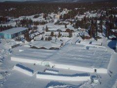
| 5' Wing, Lillehammer Olympic Ski Jump, 1 Sep 2019 Dshkr1 Dshkr2 Dshkr3 | Location in Google Maps | ||||
Karlsborg, Sweden NanoTalon & Q180 quad, west of Linkoping, Sweden 5 Sep 2019 (3 flights) |
Location in Google Maps |
||||
Preikestolen Weekend : Karlsborg, Sweden to Preikestolen, Norway 5' Wing, Windmills, Ulvstorp, Sweden, 6 Sep 2019 Dshkr1 Dshkr2 Dshkr3 |
Location in Google Maps |
||||
| 5' Wing, Rest Area, Sweden, 6 Sep 2019 Dshkr1 Dshkr2 Dshkr3 | Location in Google Maps | ||||
| 5' Wing, Oyfossen, Otra River valley, Norway, 7 Sep 2019 (2 flights) Dshkr3 | Location in Google Maps - flight #1, flight #2 | ||||
| 5' Wing + NanoTalon, Rosskreppfjorden Dam, Norway, 7 Sep 2019 (2 flights) Dshkr3 | Location in Google Maps | ||||
| 5' Wing, Ryfylke National Tourist Route, Norway, 7 Sep 2019 (2 flights) | Location in Google Maps - flight #1, flight #2 | ||||
| 5' Wing, Sandiedfjorden, Olen, Stordalsvatnet Lake, Norway, 8 Sep 2019 (3 flights) | Location in Google Maps - flight #1, flight #2, flight #3 | ||||
| Q180 quad, Langfossen waterfall, Norway, 8 Sep 2019 | Location in Google Maps | ||||
| NanoTalon + Q180 quad, Roldalsfjellet, Norway, 8 Sep 2019 (2 flights) | Location in Google Maps | ||||
| 5' Wing, slope soaring above Horda, Norway, 8 Sep 2019 | Location in Google Maps | ||||
| 5' Wing & Q180 quad, Ulevavatnet high alpine lake, Norway, 8 Sep 2019 (2 flights) | Location in Google Maps | ||||
Karlsborg, Sweden Q180 quad & 5' Wing, near Skovde, Sweden, 11 Sep 2019 (3 flights) |
Location in Google Maps - flight #1, flight #2, flight #3 |
||||
| Q180 quad, near Tivedens, Sweden, 12 Sep 2019 | Location in Google Maps | ||||
| I was home for 10 days before my next trip. | |||||
| Q180 quad, around my front yard, 21 Sep 2019 | |||||
| Q180 quad, RCMB, aerobatics, 22 & 23 Sep 2019 (2 flights) | Location in Google Maps | ||||
Utah & Nevada & Arizona, September - December 2019, 5' Wing = Runcam Split 2, Q180 & NanoTalon = Runcam Split Mini I went to Utah for 10 weeks of flight testing at Dugway Proving Grounds, 90 miles southwest of Salt Lake City. I visited parks on the weekends off. |
|||||
Utah and Arizona aerial video highlights, 25 Sep 2019 - 6 Dec 2019 Dshkr2 |
Utah and Arizona |
||||
Dugway, Utah NanoTalon, Skull Valley, Utah, 25 Sep 2019 Dshkr3 |
Location in Google Maps |
||||
| NanoTalon, Skull Valley, Utah, 27 Sep 2019 Dshkr3 | Location in Google Maps | ||||
| 5' Wing, Skull Valley, Utah, 27 Sep 2019 | Location in Google Maps | ||||
| Q180 Quad, Skull Valley, Utah, 27 Sep 2019 | Location in Google Maps | ||||
| NanoTalon, Lookout Pass, Utah, 28 Sep 2019 Dshkr1 Dshkr3 | Location in Google Maps | ||||
| NanoTalon, Simpson Springs, Utah, 28 Sep 2019 Dshkr1 Dshkr3 | Location in Google Maps | ||||
| NanoTalon, North of Simpson Springs, Utah, 28 Sep 2019 Dshkr1 Dshkr3 | Location in Google Maps | ||||
| NanoTalon, South Skull Valley, Utah, 28 Sep 2019 Dshkr1 Dshkr3 | Location in Google Maps | ||||
|
Q180 quad, Simpson Springs,
Utah, 28 Sep 2019 (3
flights) |
Location in Google Maps - flight #1, flights #2 & #3 | ||||
| 5' Wing & Q180 quad, Dry Hollow overlook, Timpanagos Highway, 29 Sep 2019 | Location in Google Maps | ||||
| NanoTalon & Q180 quad, Five Mile Pass Utah-73, 29 Sep 2019 | Location in Google Maps | ||||
| 5' Wing & NanoTalon, Fisher/Johnson Pass, Utah, 29 Sep 2019 Dshkr3 | Location in Google Maps | ||||
Zion Area Weekend Q180 quad, Candy Cliffs - Yant Flat, Utah, 5 Oct 2019 (4 flights) |
Location in Google Maps |
||||
|
5'
Wing, Access Rd 031, Red Cliffs Conservation
Area, Utah, 5 Oct 2019 (2 flights) |
Location in Google Maps - flight #1, flight #2 | ||||
Wedge to Bryce Weekend NanoTalon, Wedge Overlook, San Rafael River, 12 Oct 2019 (2 flights) Dshkr3 |
Location in Google Maps - flight #1, flight #2, |
||||
| NanoTalon, San Rafael Swell, 12 Oct 2019 (2 flights) Dshkr3 | Location in Google maps - flight #1, flight #2 | ||||
| NanoTalon, San Rafael Reef & near Hanksville, 12 Oct 2019 (2 flights) Dshkr3 | Location in Google Maps - flight #1, flight #2 | ||||
| 5' Wing, Buckhorn Draw Road, 12 Oct 2019 (2 flights) Dshkr3 | Location in Google Maps | ||||
| 5' Wing, Boulder Mountain, 13 Oct 2019 (2 flight) | Location in Google Maps - flight #1, flight #2 | ||||
| Q180 quad, Escalante Gorge, Utah-20, 13 & 14 Oct 2019 (2 flights) | Location in Google Maps - flight #1, flight #2 | ||||
Great Basin National Park Weekend NanoTalon & 5' Wing, Great Basin to Dugway, 20 Oct 2019 (3 flights) Dshkr3 |
Location in Google Maps - flight #1, flight #2, flight #3 |
||||
Dugway, Utah NanoTalon & 5' Wing, Skull Valley, 26 Oct 2019 Gear 360 on 5' Wing |
Location in Google Maps |
||||
| NanoTalon, Fisher/Johnson Pass, 27 Oct 2019 Dshkr3 | Location in Google Maps | ||||
Moab to Capitol Reef Weekend Q180 quad, Poison Spider Mesa - Moab, 3 Nov 2019 (2 flights) |
Location in Google Maps - flight #1, flight #2 |
||||
| Q180 quad, Utah-95, Burr Trail Rd, 4 & 5 Nov 2019 (2 flights) | Location in Google Maps - flight #1, flight #2 | ||||
| 5' Wing & NanoTalon, Potash Rd - settling ponds, 3 Nov 2019 (2 flights) Dshkr3 | Location in Google Maps | ||||
| 5' Wing, Potash Rd - Colorado River, 3 Nov 2019 Dshkr3 | Location in Google Maps | ||||
| 5' Wing, Utah-95, Utah-276, 4 Nov 2019 (3 flights) Dshkr3 | Location in Google Maps - flight #1, flight #2 & #3 | ||||
| 5' Wing & NanoTalon, Burr Trail Rd, 5 Nov 2019 (2 flights) Dshkr3 | Location in Google Maps - flight #1, flight #2 | ||||
| NanoTalon, Notom-Bullfrog Rd, 5 Nov 2019 (2 flights) Dshkr3 | Location in Google Maps | ||||
| NanoTalon, Moab to Needles: Utah-114 x2, Utah-211, 3 Nov 2019 (3 flights) Dshkr3 | Location in Google Maps - flight #1, flight #2, flight #3 | ||||
| NanoTalon, House On Fire trailhead, White & Fry Canyons, 4 Nov 2019 (3 flights) Dshkr3 | Location in Google Maps - flight #1, flight #2, flight #3 | ||||
| NanoTalon, White Canyon x2, Utah-95, 4 Nov 2019 (3 flights) Dshkr3 | Location in Google Maps - flight #1, flight #2, flight #3 | ||||
Dugway, Utah NanoTalon & Q180, Skull Valley, 21 Nov 2019 (3 flights) |
Location in Google Maps - flight #1, flight #2 & #3 |
||||
|
Q180 quad, Skull Valley -
White Rock, 23 Nov 2019 (2 flights) |
Location in Google Maps | ||||
| NanoTalon, Skull Valley - White Rock, 23 Nov 2019 (2 flights) Dshkr3 | Location in Google Maps - flight #1, flight #2 | ||||
Bryce - Zion - White Pocket Weekend NanoTalon & Q180 quad, White Pocket, Arizona, 26 Nov 2019 (2 flights) |
Location in Google Maps |
||||
| Q180 quad, Southeast of Hurricane, Utah, 26 Nov 2019 (2 flights) | Location in Google Maps | ||||
Dugway, Utah NanoTalon & Q180, Skull Valley, 6 Dec 2019 (3 flights) |
Location in Google Maps |
||||
| NanoTalon & Q180, Fisher/Johnson Pass, 6 Dec 2019 (2 flights) | Location in Google Maps | ||||
|
Overall highlights from
September to December 2019 for each airframe:
NanoTalon highlights, September - December 2019 Dshkr3 5' Wing highlights, September - December 2019 Dshkr2 Q180 Quad highlights, September - December 2019 Dshkr2 |
Norway - Sweden - Utah - Arizona Norway - Sweden - Utah Norway - Sweden - Utah - Arizona |
||||
|
Utah & Montana
& Idaho, June 2020 |
|||||
|
Capitol Reef National Park,
Utah (flown on BLM land near Capitol Reef) San Rafael Swell, Q200 - Runcam Split 2, 6 June 2020 Cathedral Valley - west, Q200 - Runcam Split 2, 6 June 2020 Cathedral Valley - east, NanoTalon - Runcam Split Mini, 7 June 2020, Dshkr4 Cathedral Valley - east, Q180 - Runcam Split Mini, 7 June 2020 Cathedral Valley - east, Q200 - Runcam Split 2, 7 June 2020 Caineville Wash Road, NanoTalon - Runcam Split Mini, 7 June 2020, Dshkr4 Notom-Bullfrog Road, NanoTalon - Runcam Split Mini, 7 June 2020, Dshkr4 Notom-Bullfrog Road, Q200 - Runcam Split 2, 7 June 2020 |
Location in Google Maps Location in Google Maps Location in Google Maps Location in Google Maps Location in Google Maps Location in Google Maps Location in Google Maps Location in Google Maps |
||||
|
Skull Valley, Utah Skull Valley, NanoTalon Aerial Video, 08 June 2020, Dshkr4 Skull Valley, Q180 & Q200 Aerial Video, 08 June 2020 White Rocks, NanoTalon Aerial Video, 09 June 2020 (2 flights), Dshkr4 White Rocks, Q180 Aerial Video, 09 June 2020 (3 flights) White Rocks, Q200 Aerial Video, 09 June 2020 (3 flights) |
Location In Google Maps Location In Google Maps Location In Google Maps - flight #1, flight #2 Location In Google Maps Location In Google Maps |
||||
|
White House Campground, Grand Staircase-Escalante National Monument, Utah Cottonwood Canyon Road @ Cottonwood Narrows, Q200 Aerial Video, 13 June 2020 White House Campground, NanoTalon Aerial Video, 14 & 15 June 2020 (2 flights), Dshkr4 White House Campground, Q180 & Q200 Aerial Video, 15 June 2020 (2 flights) |
Location In Google Maps Location In Google Maps Location In Google Maps |
||||
|
Montana & Idaho Hebgen Lake, Montana, NanoTalon Aerial Video, 22 June 2020, Dshkr4 Targhee Pass, Idaho, NanoTalon Aerial Video, 25 June 2020, Dshkr4 Henry's Fork River Plain, Idaho, NanoTalon Aerial Video, 25 June 2020 (2 flights), Dshkr4 Targhee Pass & Mesa Falls Scenic Byway, Idaho, Q180 Aerial Video, 25 June 2020 |
Location In Google Maps Location In Google Maps Location In Google Maps Location In Google Maps - flight #1, flight #2 |
||||
| Maryland & West Virginia, July - August 2020 | |||||
|
RCMB Flying Field, MD, Runcam Split & EV200D Goggles, CL-OSD w/ RSSI, 26 Jul 2020 RCMB Flying Field, MD, Runcam Split & EV200D Goggles, CL-OSD w/ RSSI, 7 Aug 2020 RCMB Flying Field, MD, 16' Flying Wing, Gear 360, 9 Aug 2020 RCMB Flying Field, MD, Stryker Thrust Vectored Twin, 720P Mini Camera, 9 Aug 2020 |
Location in Google Maps Location in Google Maps Location in Google Maps Location in Google Maps |
||||
|
Stonewall Resort State Park, WV, Runcam Split
Mini, Q180 Quad, 26 Aug 2020,
Dshkr4 Stonewell Resort State Park, WV, Runcam Split, 5' Wing, 26 Aug 2020, Dshkr4 |
Location in Google Maps Location in Google Maps |
||||
| RCMB Flying Field, MD, Runcam Split Mini, NanoTalon, 29 Aug 2020, Dshkr4 | Location in Google Maps | ||||
| New York & Canada & Maryland, August - September 2021 | |||||
| Watkins Glen, New York, Runcam Split, 5' Wing, 8 Aug 2021 Dshkr1 | Location in Google Maps | ||||
| Ingonish, Nova Scotia, Runcam Split Mini, NanoTalon, 22 Aug 2021 (2 flights) | Location in Google Maps | ||||
| Lower Argyle, Nova Scotia, Runcam Split Mini, NanoTalon, 28 Aug 2021, Dshkr4 Dshkr1 | Location in Google Maps | ||||
| Lower Argyle, Nova Scotia, Runcam Split Mini, Q180 Quad, 29 Aug 2021 | Location in Google Maps | ||||
| Lower Argyle, Nova Scotia, Runcam Split Mini, NanoTalon, 29 Aug 2021 | Location in Google Maps | ||||
| New Glasgow, Prince Edward Island, Runcam Split Mini, NanoTalon, 1 Sep 2021 | Location in Google Maps | ||||
| RCMB Flying Field, MD, Runcam Split Mini, Q180 Quad, Air to Air, 19 Sep 2021 | Location in Google Maps | ||||
| Utah & Nevada, October - November 2021 | |||||
| San Rafael Swell & Capitol Reef National Park Weekend |
|
||||
| Wedge Overlook, Utah, Runcam Split Mini, NanoTalon, 1 Oct 2021 | Location in Google Maps | ||||
| San Rafael River Bridge, Utah, Runcam Split, 5' Wing, 1 Oct 2021 (2 flights) | Location in Google Maps | ||||
| HWY-72 Summit, Northwest of Capitol Reef NP, Utah, Runcam Split, 5' Wing, 3 Oct 2021 | Location in Google Maps | ||||
| HWY-72 Valley, Northwest of Capitol Reef NP, Utah, Runcam Split, 5' Wing, 3 Oct 2021 | Location in Google Maps | ||||
| HWY-72 Cliffs, Northwest of Capitol Reef NP, Utah, Runcam Split Mini, Q180 Quad, 3 Oct 2021 | Location in Google Maps | ||||
| Cliff diving near Salina, Utah, Runcam Split Mini, Q180 Quad, 3 Oct 2021 (2 flights) | Location in Google Maps | ||||
| Skull Valley |
|
||||
| Lone Rock, Skull Valley, Utah, Runcam Split, 5' Wing, 4 Oct 2021 | Location in Google Maps | ||||
| Horseshoe Springs, Skull Valley, Utah, Runcam Split, 5' Wing, 6 Oct 2021 | Location in Google Maps | ||||
| Moab & San Rafael Swell Weekend |
|
||||
| Canyonlands NP, Needles District Viewpoint, Utah, Runcam Split, 5' Wing, 8 Oct 2021 | Location in Google Maps | ||||
| Canyonlands NP, Indian Creek Canyon, Utah, Runcam Split, 5' Wing, 9 Oct 2021 | Location in Google Maps | ||||
| Rock Pinnacle, Steens Rd - Utah HWY-114, Runcam Split Mini, Q180 Quad, 9 Oct 2021 | Location in Google Maps | ||||
| Castle Valley, Utah, Runcam Split, 5' Wing, 10 Oct 2021 | Location in Google Maps | ||||
| Crawford Draw, Utah, Hubsan Zino Pro+, 11 Oct 2021 | Location in Google Maps | ||||
| Crawford Draw, Utah, Runcam Split, 5' Wing, 11 Oct 2021 | Location in Google Maps | ||||
| Zion National Park Weekend |
|
||||
| Kolob Terrace, Utah, Runcam Split, 5' Wing, 24 Oct 2021 | Location in Google Maps | ||||
| Meadow Hot Springs, Utah, Runcam Split, 5' Wing, 24 Oct 2021 | Location in Google Maps | ||||
| Skull Valley & Salt Lake City |
|
||||
| Southern Skull Valley, Utah, Runcam Split, 5' Wing, 28 Oct 2021 | Location in Google Maps | ||||
| Emigration Canyon, Salt Lake City, Utah, Runcam Split, 5' Wing, 30 Oct 2021 (2 flights) | Location in Google Maps | ||||
| Mt Nebo Scenic Byway, Utah, Runcam Split, 5' Wing, 31 Oct 2021 | Location in Google Maps | ||||
| Johnson Pass, Utah, Runcam Split, 5' Wing, 31 Oct 2021 | Location in Google Maps | ||||
| Southern Skull Valley, Utah, Runcam Split Mini, Q180 Quad, 3 Nov 2021 (4 flights) | Location in Google Maps | ||||
| Southern Skull Valley, Utah, Runcam Split, 5' Wing, 3 Nov 2021 | Location in Google Maps | ||||
| Southern Skull Valley, Utah, Hubsan Zino Pro+, 3 Nov 2021 (2 flights) | Location in Google Maps | ||||
| Cathedral Gorge State Park, Nevada | |||||
| Eagle Point Trailhead, Cathedral Gorge State Park, Nevada, Runcam Split, 5' Wing, 6 Nov 2021 | Location in Google Maps | ||||
| Miller Point, Cathedral Gorge State Park, Nevada, Hubsan Zino Pro+, 6 Nov 2021 (1080) | Location in Google Maps | ||||
| Miller Point, Cathedral Gorge State Park, Nevada, Hubsan Zino Pro+, 6 Nov 2021 (4K) | Location in Google Maps | ||||
| Grand Staircase - Escalante National Monument & Capitol Reef National Park Weekend |
|
||||
| Upper Calf Creek Falls, Grand Staircase-Escalante NM, Utah, Hubsan Zino Pro+, 11 Nov 2021 | Location in Google Maps | ||||
| Devils Garden, Grand Staircase-Escalante NM, Utah, Hubsan Zino Pro+, 12 Nov 2021 (2 flights) | Location in Google Maps | ||||
| Zebra Slot Trailhead, Grand Staircase-Escalante NM, Utah, Runcam Split, 5' Wing, 12 Nov 2021 | Location in Google Maps | ||||
| Little Death Hollow Campsite, Grand Staircase-Escalante NM, Utah, Hubsan Zino Pro+, 13 Nov 2021 | Location in Google Maps | ||||
| Little Death Hollow Trailhead, Grand Staircase-Escalante NM, Utah, Runcam Split, 5' Wing, 13 Nov 2021 | Location in Google Maps | ||||
| Cathedral Valley Road - bentonite hills, Utah, Runcam Split Mini, Q180 Quad, 14 Nov 2021 (2 flights) | Location in Google Maps | ||||
| Cathedral Valley Road - bentonite hills, Utah, Runcam Split, 5' Wing, 14 Nov 2021 | Location in Google Maps | ||||
| Cathedral Valley Road - bentonite hills, Utah, Hubsan Zino Pro+, 14 Nov 2021 | Location in Google Maps | ||||
| Notom, Utah, Runcam Split, 5' Wing, 14 Nov 2021 | Location in Google Maps | ||||
| Torrey - west entrance to Capitol Reef NP, Utah, Runcam Split, 5' Wing, 14 Nov 2021 | Location in Google Maps | ||||
| Skull Valley & Salt Lake City |
|
||||
| Southern Skull Valley, Utah, Runcam Split, 5' Wing, 20 Nov 2021 Dshkr1 Dshkr4 | Location in Google Maps | ||||
| Saltair, Great Salt Lake, Utah, Runcam Split, 5' Wing, 20 Nov 2021 Dshkr1 Dshkr4 | Location in Google Maps | ||||
| Arizona & California - February 2022 | |||||
| Kofa National Wildlife Refuge, Arizona, Caddx Loris 2.7K, NanoTalon, 10 Feb 2022 | Location in Google Maps | ||||
| Adair Road RC Flying Field, Yuma, Arizona, Caddx Loris 2.7K, NanoTalon, 10 Feb 2022 | Location in Google Maps | ||||
| Adair Road RC Flying Field, Yuma, Arizona, Runcam Split, 5' Wing, 12 Feb 2022 (3 flights) | Location in Google Maps | ||||
| Lake Havasu, Arizona, Runcam Split, 5' Wing, 12 Feb 2022 | Location in Google Maps | ||||
| The Slot, Anza-Borrego Desert State Park, California, Runcam Split, 5' Wing, 13 Feb 2022 | Location in Google Maps | ||||
| Laguna Mountains, California, Runcam Split, 5' Wing, 13 Feb 2022 | Location in Google Maps | ||||
| Kofa National Wildlife Refuge, Arizona, Runcam Split, 5 Wing, 14 Feb 2022 | Location in Google Maps | ||||
| Adair Road RC Flying Field, Yuma, Arizona, Runcam Split, 5' Wing, 14 Feb 2022 | Location in Google Maps | ||||
| Adair Road RC Flying Field, Yuma, Arizona, Caddx Loris 2.7K, NanoTalon, 14 Feb 2022 | Location in Google Maps | ||||
| Sedona, Arizona, Runcam Split, 5' Wing, 17 Feb 2022 (2 flights) | Location in Google Maps | ||||
| Arizona & California & Utah - July 2022 | |||||
| McPhaul Bridge, Yuma, Arizona, Hubsan Zino Pro+ 4K, 20 July 2022 | Location in Google Maps | ||||
| Borrego Springs, California, Hubsan Zino Pro+ 4K, 23 July 2022 | Location in Google Maps | ||||
| Yuma Crossing, Yuma, Arizona, Hubsan Zino Pro+ 4K, 25 July 2022 | Location in Google Maps | ||||
| Yant Flats / Candy Cliffs, St George, Utah, Hubsan Zino Pro+ 4K, 28 July 2022 | Location in Google Maps | ||||
| Toadstool Hoodoos, Big Water, Utah, Hubsan Zino Pro+ 4K, 29 July 2022 | Location in Google Maps | ||||
| New York & Maryland & Florida - September 2022 | |||||
| Sheldrake Winery, Cayuga Lake, New York, Hubsan Zino Pro+ 4K, 4 September 2022 | Location in Google Maps | ||||
| Sandy Point State Park, Annapolis, Maryland, Hubsan Zino Pro+ 4K, 9 September 2022 | Location in Google Maps | ||||
| Panama City Beach, Florida, Hubsan Zino Pro+ 4K, 19 September 2022 | Location in Google Maps | ||||
| West Virginia & Maryland & New Orleans - October 2022 | |||||
| Kanawha Falls, West Virginia, Hubsan Zino Pro+ 4K, 17 October 2022 | Location in Google Maps | ||||
| RCMB Flying Field, Maryland, Hubsan Zino Pro+ 4K, 22 October 2022 | Location in Google Maps | ||||
| Ft Pike State Historic Site, Louisiana, Hubsan Zino Pro+ 4K, 26 October 2022 | Location in Google Maps | ||||
| Ft Macomb, Louisiana, Hubsan Zino Pro+ 4K, 28 October 2022 | Location in Google Maps | ||||
| Woldenberg Park, New Orleans, Louisiana, Hubsan Zino Pro+ 4K, 30 October 2022 | Location in Google Maps | ||||
| Arizona & California & Utah - December 2022 | |||||
| Sedona, Arizona, Near the Honanki Heritage Site, Hubsan Zino Pro+ 4K, 3 December 2022 | Location in Google Maps | ||||
| South of Phoenix, Arizona, Caddx Orca 4K in Caipirinha Wing, 5 December 2022 | Location in Google Maps | ||||
| Yuma Foothills, Arizona, Caddx Orca 4K in Caipirinha Wing, 5 December 2022 | Location in Google Maps | ||||
| Adair Rd RC Field, Yuma, Arizona, Caddx Orca 4K in Caipirinha Wing, 6 December 2022 | Location in Google Maps | ||||
| Adair Rd RC Field, Yuma, Arizona, Caddx Orca 4K in 5" Quad, 6 December 2022 | Location in Google Maps | ||||
| Yuma, Arizona, Caddx Orca 4K in Caipirinha Wing, 8 December 2022 | Location in Google Maps | ||||
| Castle Dome Peak, Arizona, Hubsan Zino Pro+ 4K, 10 December 2022 | Location in Google Maps | ||||
| Picacho Slot Canyons, California, Caddx Orca 4K in 5" Quad, 11 December 2022 #1 | Location in Google Maps | ||||
| Picacho SRA, California, Caddx Orca 4K in Caipirinha Wing, 11 December 2022 | Location in Google Maps | ||||
| Picacho Slot Canyons, California, Caddx Orca 4K in 5" Quad, 11 December 2022 #2 | Location in Google Maps | ||||
| Picacho Slot Canyons, California, Hubsan Zino Pro+ 4K, 11 December 2022 | Location in Google Maps | ||||
| Picacho Slot Canyons, California, Caddx Orca 4K in 5" Quad, 11 December 2022 #3 | Location in Google Maps | ||||
| Adair Rd RC Field, Yuma, Arizona, Caddx Orca 4K in 5" Quad, 12 December 2022 (2 flights) | Location in Google Maps | ||||
| Adair Rd RC Field, Yuma, Arizona, Caddx Orca 4K in Caipirinha Wing, 12 December 2022 | Location in Google Maps | ||||
| Sedona, Arizona, Hubsan Zino Pro+ 4K, 17 December 2022 | Location in Google Maps | ||||
| Cottonwood Canyon Rd, GSENM, Utah, Caddx Orca 4K in Caipirinha Wing, 18 December 2022 | Location in Google Maps | ||||
| Hoodoo Forest, GSENM, Utah, Hubsan Zino Pro+ 4K, 18 December 2022 | Location in Google Maps | ||||
| Cottonwood Canyon Rd, GSENM, Utah, Caddx Orca 4K in 5" Quad, 18 December 2022 | Location in Google Maps | ||||
| Observation Point, South of Page, Arizona, Hubsan Zino Pro+ 4K, 19 December 2022 | Location in Google Maps | ||||
| Observation Point, South of Page, Arizona, Caddx Orca 4K in 5" Quad, 19 December 2022 | Location in Google Maps | ||||
| Vermillion Cliffs, Arizona, Caddx Orca 4K in 5" Quad, 19 December 2022 | Location in Google Maps | ||||
| Echo Cliffs, Arizona, Caddx Orca 4K in Caipirinha Wing, 19 December 2022 | Location in Google Maps | ||||
| Sedona, Arizona, Caddx Orca 4K in 5" Quad, 19 December 2022 | Location in Google Maps | ||||
| Arizona - January 2023 | |||||
| Gila River, Yuma, Arizona, Hubsan Zino Pro+ 4K, 9 January 2023 | Location in Google Maps | ||||
| Kofa Mountains, Quartzsite, Arizona, Hubsan Zino Pro+ 4K, 11 January 2023 | Location in Google Maps | ||||
| Phoenix Raceway, Arizona, Hubsan Zino Pro+ 4K, 12 January 2023 | Location in Google Maps | ||||
| Arizona - February 2023 | |||||
| Adair Road RC Field, Yuma, Arizona, Caddx Orca 4K, 3 February 2023 | Location in Google Maps | ||||
| Stonewall Peak & Borrego Springs, California, Hubsan Zino Pro+ 4K, 4 February 2023 | Location in Google Maps - flight #1, flight #2 | ||||
| Picacho Desert Location #1, California, Caddx Orca 4K, 5 February 2023 | Location in Google Maps | ||||
| Picacho Desert Location #2, California, Caddx Orca 4K, 5 February 2023 | Location in Google Maps | ||||
| Picacho Desert Location #2, California, Caddx Orca 4K, 5 February 2023 | Location in Google Maps | ||||
| Picacho Desert Location #1, California, Hubsan Zino Pro+ 4K, 5 February 2023 | Location in Google Maps | ||||
| Picacho Desert Location #2, California, DJI Mavik Pro 4K, 5 February 2023 | Location in Google Maps | ||||
| Yuma Territorial Prison, Yuma, Arizona, DJI Mavik Pro 4K, 5 February 2023 | Location in Google Maps | ||||
| Colorado & Gila River Confluence, Yuma, Arizona, DJI Mavik Pro 4K, 5 February 2023 | Location in Google Maps | ||||
| Adair Road RC Field, Yuma, Arizona, Caddx Orca 4K, 7 February 2023 | Location in Google Maps | ||||
| Adair Road RC Field, Yuma, Arizona, DJI Mavik Pro 4K, 7 February 2023 | Location in Google Maps | ||||
| Adair Road RC Field, Yuma, Arizona, DJI Mavik Pro 4K, 10 February 2023 | Location in Google Maps | ||||
| Picacho Desert Location #3, California, Caddx Orca 4K, 11 February 2023 | Location in Google Maps | ||||
| Picacho Desert Location #3, California, Caddx Orca 4K, 11 February 2023 | Location in Google Maps | ||||
| Picacho Desert Location #3, California, Hubsan Zino Pro+ 4K + DJI Mavik Pro 4K, 11 February 2023 | Location in Google Maps | ||||
| Adair Road RC Field, Yuma, Arizona, Caddx Orca 4K, 12 February 2023 | Location in Google Maps | ||||
| Muggins Mountain Wilderness, Yuma, Arizona, Caddx Orca 4K, 12 February 2023 | Location in Google Maps | ||||
|
Video Processing with GyroFlow, Video Overlays with VirbEdit Gyroflow https://gyroflow.xyz/ - drag multiple GoPro video files to main interface. Gyroflow will ask if you want to combine the files. YES - output will be first_filename_joined.mp4. - this could also be done by MP4 Joiner, but Gyroflow does the job faster. - the combined video file has not been re-encoded and all extra tracks, such as telemetry, are preserved. - complete stabilization, filename will be xxxxx_stabilized.mp4 Telemetry Extractor for GoPro Lite https://goprotelemetryextractor.com/free/ - select Free option, drag _joined.mp4 video file to main screen - GPS data: - Set Frequency at 1 hz (Virb Edit does not calculate 2D speed at other rates correctly) - Select Virb Edit; this is GPX data optimized for Virb Edit - data will generate and download to 'Downloads' directory, copy to folder with video - Accelerometer: - Set Frequency at frame rate - Select Virb Edit; this is GPX data optimized for Virb Edit There is lots more data available in the GoPro recording, but these are the only outputs available for Virb Edit from Telemetry Extractor. Virb Edit https://www.garmin.com/en-US/p/573412 - drag _joined_stabilized.mp4 file to main screen - import GPS data .GPX and accelerometers .GPX data - set up text and graphic overlays - export video |
|||||
| US East Coast - Summer Fall Winter 2023 | |||||
| High Rocks, Monongahela National Forest, West Virginia, DJI Mavik Pro 4K, 27 May 2023 | Location in Google Maps | ||||
| RCMB Flying Field, Maryland, Caddx Orca 4K, 27 August 2023 | Location in Google Maps | ||||
| RCMB Flying Field, Maryland, GoPro Session 5 4K, 1 September 2023, + Gyroflow (0.4) | Location in Google Maps | ||||
| RCMB Flying Field, Maryland, GoPro Hero 10 2.7K, 1 September 2023, + Gyroflow (0.4) | Location in Google Maps | ||||
| RCMB Flying Field, Maryland, GoPro Hero 10 4K, 1 September 2023, + Gyroflow (0.5) + VIRB Overlays | Location in Google Maps | ||||
| RCMB Flying Field, Maryland, GoPro Session 5 4K, 2 September 2023, + Gyroflow (0.4) | Location in Google Maps | ||||
| RCMB Flying Field, Maryland, GoPro Hero 10 4K, 2 September 2023, + Gyroflow (0.4) | Location in Google Maps | ||||
| RCMB Flying Field, Maryland, GoPro Hero 10 4K, 2 September 2023, + Gyroflow (0.5) + VIRB Overlays | Location in Google Maps | ||||
| Miami Beach, Florida, DJI Mavik Pro 4K, 10 September 2023 | Location in Google Maps | ||||
| Duck Key / 7-Mile Bridge, Florida, DJI Mavik Pro 4K, 13 September 2023 | Location in Google Maps | ||||
| NCR Rail Trail, Maryland & Pennsylvania, DJI Mavik Pro 4K, 29 September 2023 | Location in Google Maps - flight #1, flight #2 | ||||
| RCMB Flying Field, Maryland, GoPro Session 5 4K, 30 September 2023, + Gyroflow (0.4) | Location in Google Maps | ||||
| RCMB Flying Field, Maryland, GoPro Hero 10 4K, 1 October 2023, + Gyroflow (0.5) | Location in Google Maps | ||||
| RCMB Flying Field, Maryland, GoPro Hero 10 4K, 1 October 2023, + Gyroflow (0.5) + VIRB Overlays | Location in Google Maps | ||||
| RCMB Flying Field, Maryland, Caddx Orca 4K, NanoTalon, 1 October 2023 | Location in Google Maps | ||||
| RCMB Flying Field, Maryland, GoPro Session 5 4K, Hyperlow Quad, 1 October 2023 | Location in Google Maps | ||||
| RCMB Flying Field, Maryland, Gear 360 4K, 13' Flying Wing, 1 October 2023 | Location in Google Maps | ||||
| RCMB Flying Field, Maryland, GoPro Hero 10 4K, 28 October 2023, + Gyroflow (0.5) + VIRB Overlays | Location in Google Maps | ||||
| RCMB Flying Field, Maryland, Stryker Twin Flat Spin @ 225 RPM, 5 November 2023 | Location in Google Maps | ||||
| RCMB Flying Field, Maryland, GoPro Hero 10 4K, 5 November 2023, + VIRB Overlays | Location in Google Maps | ||||
| RCMB Flying Field, Maryland, Half Shadow, Gear360 4K, 13 November 2023, flight #1 | Location in Google Maps | ||||
| RCMB Flying Field, Maryland, Half Shadow, Gear360 4K, 13 November 2023, flight #2 | Location in Google Maps | ||||
| RCMB Flying Field, Maryland, 5.5' Wing, Gear360 4K, 13 November 2023, flight #1 | Location in Google Maps | ||||
| RCMB Flying Field, Maryland, 5.5' Wing, Gear360 4K, 13 November 2023, flight #2 | Location in Google Maps | ||||
| 2024 | |||||
| Costa Rica, Rio Celeste & La Fortuna, DJI Mavik Pro 4K, 6 & 8 January 2024 | Location in Google Maps - flight #1, flight #2 | ||||
| Costa Rica, Lake Arenal, DJI Mavik Pro 4K, 9 January 2024 | Location in Google Maps | ||||
| Costa Rica, Monteverde, DJI Mavik Pro 4K, 9 & 10 January 2024 | Location in Google Maps | ||||
| Costa Rica, Mirador Los Olivos - El Tigre Waterfalls, DJI Mavik Pro 4K, 10 January 2024 | Location in Google Maps | ||||
| Costa Rica, Playa Conchal, DJI Mavik Pro 4K, 13 January 2024 | Location in Google Maps | ||||
| Costa Rica, Playa Conchal Catamara Cruise, DJI Mavik Pro 4K, 15 January 2024 | Location in Google Maps | ||||
| Costa Rica, Papagayo Peninsula, DJI Mavik Pro 4K, 18 January 2024 | Location in Google Maps | ||||
| Costa Rica, Monteverde, DJI Mavik Pro 4K, 13 January 2024 | Location in Google Maps | ||||
| Mazatlan, Mexico, Solar Eclipse, DJI Mavik Pro 4K, 8 April 2024 | Location in Google Maps | ||||
| Puerto Vallarta, Mexico, DJI Mavik Pro 4K, 11 April 2024 | Location in Google Maps | ||||
| RCMB Flying Field, Maryland, GoPro Hero 10 4K, 5 May 2024 | Location in Google Maps | ||||
| RCMB Flying Field, Maryland, GoPro Session 5 4K & Caddx Orca 4K, 17 May 2024 | Location in Google Maps | ||||
| RCMB Flying Field, Maryland, GoPro Session 5 4K, 17 May 2024, + GyroFlow (0.5) | Location in Google Maps | ||||
| Borrego Springs, California, GoPro 10 4K, 28 May 2024, + GyroFlow (0.5) | Location on All-Trails Map | ||||
| Lake Henshaw, California, GoPro 10 4K, 28 May 2024, + GyroFlow (0.5) | Location in Google Maps | ||||
| Little Finland, Nevada, DJI Mavik Pro 4K, 3 June 2024 (sunrise - flight #1) | Location in Google Maps | ||||
| Little Finland, Nevada, DJI Mavik Pro 4K, 3 June 2024 (flight #2) | Location in Google Maps | ||||
| Little Finland, Nevada, GoPro 10 4K, 3 June 2024, + GyroFlow (0.5) | Location in Google Maps | ||||
| Little Finland, Nevada, GoPro 10 4K, 3 June 2024, + GyroFlow (0.5) + VirbEdit | Location in Google Maps | ||||
| Virgin River, Nevada, GoPro 10 4K, 3 June 2024, + GyroFlow (0.5) | Location in Google Maps | ||||
| White House Campground, Utah, GoPro 10 4K, 5 June 2024, + GyroFlow (0.5) | Location in Google Maps | ||||
| White House Campground, Utah, DJI Mavik Pro 4K, 5 June 2024 (daytime) | Location in Google Maps | ||||
| White Pocket, Arizona, DJI Mavik Pro 4K, 5 June 2024 | Location in Google Maps | ||||
| White House Campground, Utah, DJI Mavik Pro 4K, 5 June 2024 (sunset) | Location in Google Maps | ||||
| Cottonwood Canyon Road, Cottonwood Narrows, Utah, DJI Mavik Pro 4K, 6 June 2024 | Location in Google Maps | ||||
| Grosvenor Arch, Utah, DJI Mavik Pro 4K, 6 June 2024 | Location in Google Maps | ||||
| Boulder City Dry Lake, Nevada, GoPro 10 4K, 8 June 2024, + GyroFlow (0.5) | Location in Google Maps | ||||
| RCMB Flying Field, Maryland, GoPro Hero 10 4K, 16 June 2024, + GyroFlow (0.5) | Location in Google Maps | ||||
| RCMB Flying Field, Maryland, GoPro Session 5 4K, 16 June 2024, + GyroFlow (0.5) | Location in Google Maps | ||||
| RCMB Flying Field, Maryland, GoPro Session 5 4K, 23 June 2024, + GyroFlow (0.5) | Location in Google Maps | ||||
| Meteora, Greece, DJI Mavik Pro 4K, 5 July 2024 | Location in Google Maps | ||||
| Kleftiko, Milos Island, Greece, DJI Mavik Pro 4K, 13 July 2024 | Location in Google Maps | ||||
| Pollonia, Milos Island, Greece, DJI Mavik Pro 4K, 13 July 2024 | Location in Google Maps | ||||
| Sarakiniko Beach, Milos Island, Greece, DJI Mavik Pro 4K, 14 July 2024 | Location in Google Maps | ||||
| Oia, Santorini, Greece, DJI Mavik Pro 4K, 16 July 2024 | Location in Google Maps | ||||
| RCMB Flying Field, Maryland, GoPro Session 5 4K, 28 July 2024, + GyroFlow & Color Adjustment | Location in Google Maps | ||||
| RCMB Flying Field, Maryland, GoPro Hero 10 4K, 2 August 2024, + GyroFlow (0.5) | Location in Google Maps | ||||
| RCMB Flying Field, Maryland, Hubsan Zino Pro+ 4K, 3 August 2024 | Location in Google Maps | ||||
| Lodi Point, Seneca Lake, Finger Lakes, New York, DJI Mavik Pro 4K, 18 August 2024 | Location in Google Maps | ||||
| RCMB Flying Field, Maryland, GoPro Session 5 4K, 24 August 2024, + GyroFlow (0.1) | Location in Google Maps | ||||
| RCMB Flying Field, Maryland, GoPro Session 5 4K, 24 August 2024, + GyroFlow (0.5) Comparison | Location in Google Maps | ||||
| RCMB Flying Field, Maryland, GoPro Session 5 4K, 25 August 2024, + GyroFlow (0.1) | Location in Google Maps | ||||
| RCMB Flying Field, Maryland, GoPro Hero 10 4K, 24 & 25 August 2024, VIRB Overlays | Location in Google Maps | ||||
| RCMB Flying Field, Maryland, GoPro Session 5 4K, 30 August 2024, + GyroFlow (0.1) | Location in Google Maps | ||||
| RCMB Flying Field, Maryland, GoPro Session 5 4K, 2 September 2024, + GyroFlow (0.2) | Location in Google Maps | ||||
| 2025 | |||||
| RCMB Flying Field, Maryland, GoPro 10 & Session 5 4K, 11 January 2025, + GyroFlow (0.5) | Location in Google Maps | ||||
| RCMB Flying Field, Maryland, GoPro 10 & Session 5 4K, 12 January 2025, + GyroFlow (0.5) | Location in Google Maps | ||||
| Negril, Jamaica, DJI Mavik Pro 4K, 23 January 2025 | Location in Google Maps | ||||
| Possum Kingdom Lake, Texas, DJI Mavik Pro 4K, 28 February 2025 | Location in Google Maps | ||||
| GSWAM Flying Field, Ft Worth, Texas, GoPro Session 5 4K, 1 March 2025 + GyroFlow (0.5) | Location in Google Maps | ||||
| GSWAM Flying Field, Ft Worth, Texas, Hubsan Zino Pro+ 4K, 1 March 2025 | Location in Google Maps | ||||
| GSWAM Flying Field, Ft Worth, Texas, GoPro Hero 4K, 2 March 2025 + Quik Stabilization | Location in Google Maps | ||||
| GSWAM Flying Field, Ft Worth, Texas, GoPro Hero 4K, 7 March 2025 + Quik Stabilization | Location in Google Maps | ||||
| Turner Falls, Oklahoma, GoPro Hero 4K, 9 March 2025 + Quik Stabilization | Location in Google Maps | ||||
| Cape Canaveral, Florida, DJI Mavik Pro 4K, 24 March 2025 | Location in Google Maps | ||||
| GSWAM Flying Field, Ft Worth, Texas, GoPro Hero 4K, April & May 2025 + Quik Stabilization | Location in Google Maps | ||||
| Turkey, Texas, Hubsan Zino Pro+ 4K, 9 May 2025 | Location in Google Maps | ||||
| GSWAM Flying Field, Ft Worth, Texas, Hubsan Zino Pro+ 4K, 11 May 2025 | Location in Google Maps | ||||
| GSWAM Flying Field, Ft Worth, Texas, DJI Mavik Pro 4K, 11 May 2025 | Location in Google Maps | ||||
| Andorra, Pyrenees Mountains, DJI Mavik Pro 4K, 1 June 2025 | Location in Google Maps | ||||
| St Emilion, France, DJI Mavik Pro 4K, 6 June 2025 | Location in Google Maps | ||||
| Sauternes, France, DJI Mavik Pro 4K, 7 June 2025 | Location in Google Maps | ||||
| GSWAM Flying Field, Ft Worth, Texas, GoPro Hero 10 4K #1, 20 July 2025 + GyroFlow (0.5) | Location in Google Maps | ||||
| GSWAM Flying Field, Ft Worth, Texas, GoPro Hero 10 4K #2, 20 July 2025 + GyroFlow (0.5) | Location in Google Maps | ||||
| GSWAM Flying Field, Ft Worth, Texas, GoPro Session 5 4K, 20 July 2025 + GyroFlow (0.5) | Location in Google Maps | ||||
| GSWAM Flying Field, Ft Worth, Texas, Caddx Orca 4K, 20 July 2025 | Location in Google Maps | ||||
| GSWAM Flying Field, Ft Worth, Texas, GoPro Session 5 4K, 27 July 2025 + GyroFlow (0.5) | Location in Google Maps | ||||
| 2026 | |||||
| GSWAM Flying Field, Ft Worth, Texas, GoPro Hero 4K, 22 Feb 2026 + Quick Stabilization | Location in Google Maps | ||||
| GSWAM Flying Field, Ft Worth, Texas, GoPro Session 5 4K, 27 Feb 2026 + GyroFlow (0.5) | Location in Google Maps | ||||
| RCMB Flying Field, Maryland, DJI Mavik Pro 4K, 11 April 2026 | Location in Google Maps | ||||
| GSWAM Flying Field, Ft Worth, Texas, GoPro Hero 4K, 24 April 2026 + Quik Stabilization | Location in Google Maps | ||||
| GSWAM Flying Field, Ft Worth, Texas, GoPro Hero 4K, 24 April 2026 + Quik Stabilization | Location in Google Maps | ||||
| GSWAM Flying Field, Ft Worth, Texas, GoPro Hero 4K, 24 April 2026 + Quik Stabilization + Meta Glasses | Location in Google Maps | ||||
| GSWAM Flying Field, Ft Worth, Texas, GoPro Hero 4K, 24 April 2026 + Quik Stabilization + Meta Glasses | Location in Google Maps | ||||
| GSWAM Flying Field, Ft Worth, Texas, GoPro Hero 10 4K, 22 May 2026 + GyroFlow (0.5) | Location in Google Maps | ||||
| GSWAM Flying Field, Ft Worth, Texas, GoPro Hero 4K, 22 May 2026 + Quik Stabilization | Location in Google Maps | ||||
| GSWAM Flying Field, Ft Worth, Texas, GoPro Hero 4K, 25 May 2026 + Quik Stabilization | Location in Google Maps | ||||
| Moab, Utah, Near Fisher Towers, GoPro Hero 4K, 18 June 2026 + Quik Stabilization | Location in Google Maps | ||||
| Blanding, Utah, Near Canyonlands Needles District, GoPro Hero 4K, 21 June 2026 + Quik Stabilization | Location in Google Maps | ||||
| Hanksville, Utah, Factory Butte, GoPro Hero 4K, 22 June 2026 + Quik Stabilization | Location in Google Maps | ||||
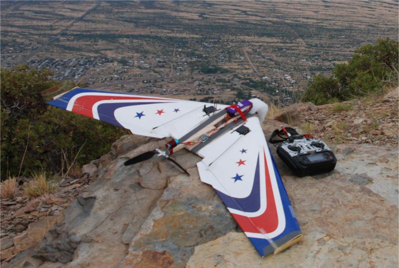
Aerial Photography & Video - Aircraft and Ground Equipment
This section shows the aircraft and ground equipment that I have used over the years to capture photos and video.
  |
Klingberg Wing x2
: This was my first large flying wing, which I built in 1990. It was 11' across
and flew for a long time on an OS 61 engine. I converted it to electric
and flew it that way, both tractor and pusher. I mounted my first
digital camera into this wing in 2000. It was an Olympus D450,
with a servo to close the shutter.
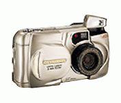
The images were not very good, so it only flew a couple times like this. Olympus D450 Cost : $250, 1.3 megapixel, 1280 x 1024, memory: Smartmedia 8MB to 128MB |
 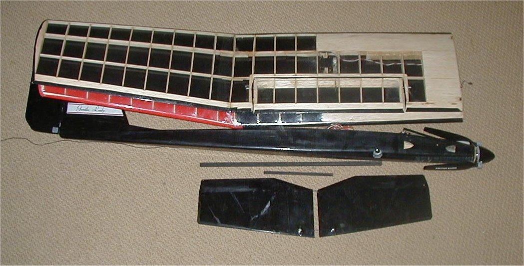 |
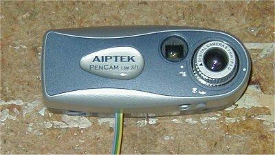
Gentle Lady : Kit built, modified wing and empennage. I added dual flaps / speed-brakes to each wing and replaced the stock tail with a removable full-flying horizontal stabilizer. Everything came apart to fit into a box as checked luggage on commercial flights. This carried the Aiptek Pencam SD. Speed 400, 3:1 planetary gearbox, 11x6 folding prop, 15 amp ESC, five channels [ rudder(1), elevator(1), flaps(2), camera shutter, throttle (ESC)] |
 |
Astro Challenger : Kit built wing and empanage, body from scratch. This carried the Aiptek Pencam SD. Speed 400, 3:1 planetary gearbox, 11x6 folding prop, 15 amp ESC, four channels [ rudder(1), elevator(1), camera shutter, throttle (ESC)] |
 |
Camera Plane #1 : The original fuselage was thrown away, but the wings and tail lived on in the improved Camera Plane #2. This carried the HP E317 camera. The two elerudders were secured by nylon screws and were removable for travel. 20x40 brushless inrunner, 6:1 gearbox, 18 amp ESC, four channels [elerudders(2), throttle(ESC), shutter] |
 |
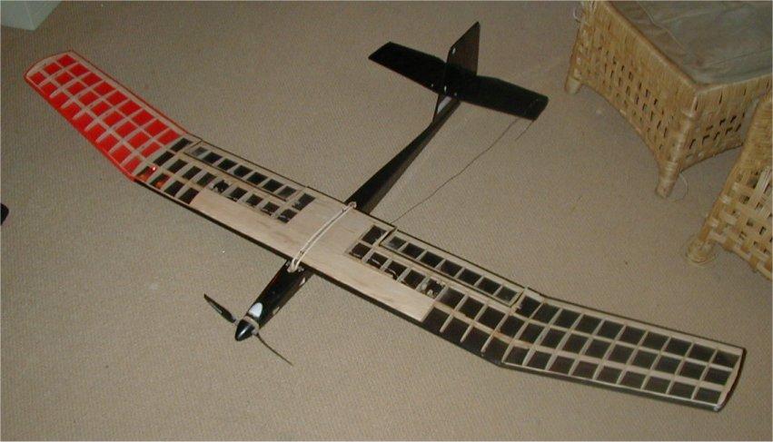
Camera Plane #2: I took the wing, empennage, motor, and speed control from my original camera plane #1 above and built this new version. It used twin booms so it had a much stiffer tail assembly, and it had room for a Sony Bloggie HD digital video camera looking out the nose, and the HP E317 digital still camera looking out either side under the wing. The whole thing came apart into small pieces to fit in small box for traveling, and the full foam fuselage protected the camera much better than camera plane #1. Four channels [ elerudder(2), throttle(ESC), shutter] |
 |
Camera Wing #1: Made from a wing set for Great Planes Slinger Flying Wing ARF. This carried the HP E317 camera, which could be mounted looking down or forward. EPP center section added to hold camera, battery, motor, ESC, and receiver. Originally powered by Himax inrunner and gearbox. Later converted to a 450 outrunner and 40 amp ESC for NightWing version, four channels [elevons(2), throttle(ESC), shutter] |
 |
Camera Wing #2: Almost the same design as Camera Wing #1, but the HP E317 camera looked to the side instead of ahead or down. Made from a second wing set for a Great Planes Slinger Flying Wing ARF. EPP center section added to hold camera, battery, motor, ESC, and receiver. I took both camera wings with me all over the US in 2009, on an extended work trip and vacation for 10 weeks and over 12,000 miles of driving. The best aerial photos from that trip are here at RC Groups. Originally powered by Himax inrunner and gearbox. Later converted to a 450 outrunner and 40 amp ESC for NightWing version, four channels [elevons(2), throttle(ESC), shutter] |
 |
F-27 Stryker : EPP foam, The originally carried the Aiptek Pencam SD, with the camera looking out the side of the nose. I later installed a Cylops camera/DVR, battery voltage OSD, and 5.8 Ghz video downlink in the nose, but have taken that FPV equipment out as the video was too shaky in this light plane. I will fly this plane just about anywhere, since it is almost indestructible. 2410-09 outrunner and 18 amp ESC, four channels [ stabilizer on/off, elevons(2 servo), throttle (ESC) ] |
 |
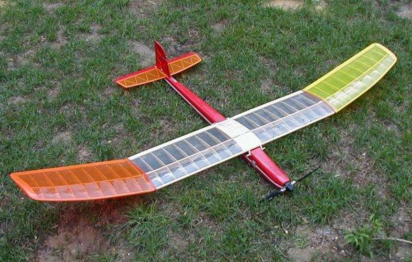
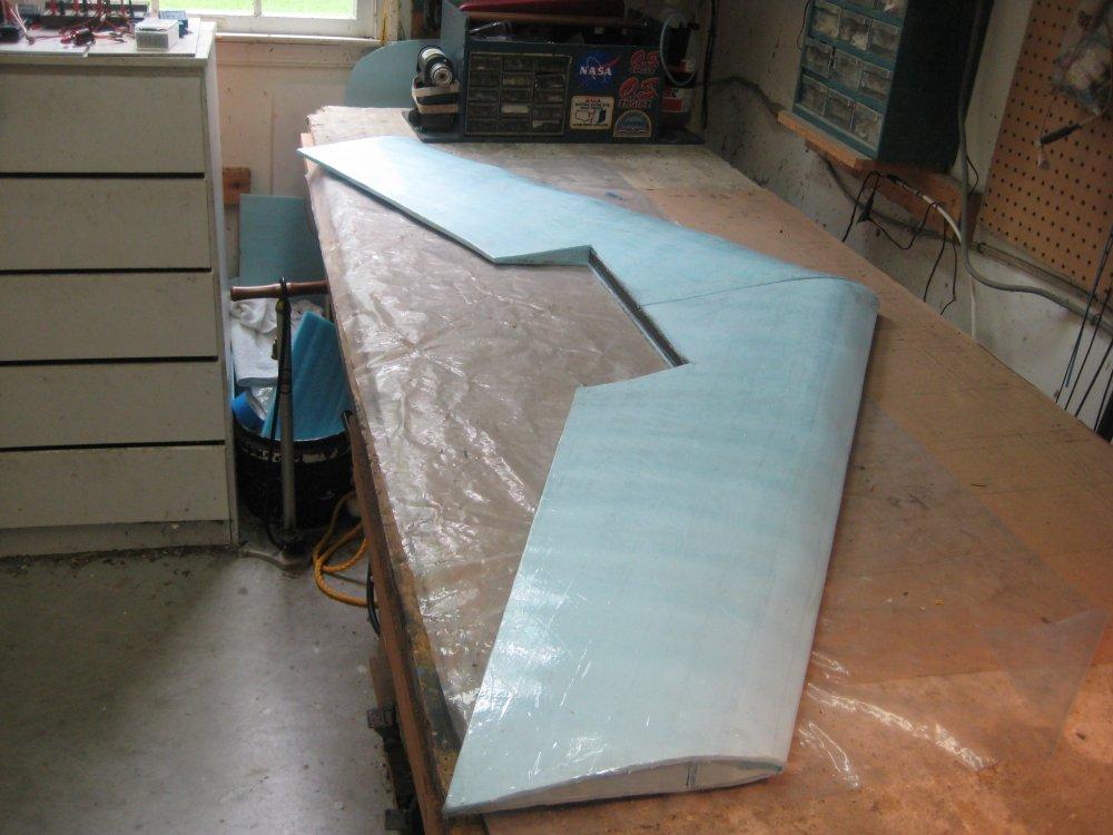
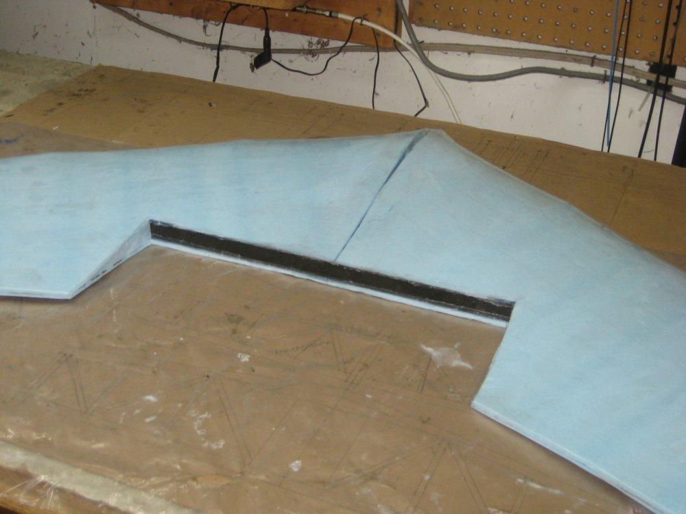
Blue & Pink Wings : two meter wingspan, 480 outrunner, 40 amp ESC, FPV and mounts for GoPro-type cameras. These flying wings are made from blue and pink fan-foldfoam. They have 2 meter wingspans and the main strength comes from carbon fiber inlays on the foam spars and cross bracing. Photos of the construction are here, here, and here. |
  |
Night Wings w/ Camera : Camera Wings #1 and #2 from above both have new center sections, and are covered with LEDs for night flight. In addition to the LEDs, Night Wing #1 has a mount to hold a GoPro, and Night Wing #2 has an internal compartment to hold a Sony Bloggie HD video camera. |
|
|
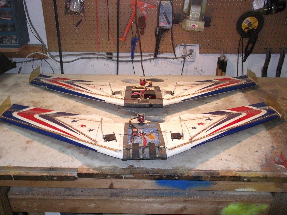
5 Foot Wingspan FPV Pink Travel Wing FPV - I built this wing for traveling, using the same separating wing sections as the 6' travel wing, but the overall span is only 5 feet to allow it to fit in smaller luggage. Power comes from a 450 outruner and 50A ESC. Control is through a Lemon 7ch DSMX stabilized receiver + Lemon satellite receiver, and the FPV section has had various 5.8 GHz video transmitters and cameras, including an Eachine Racer 250 600mW 5.8GHz video transmitter with built-in voltage & timer OSD, Runcam Split 2 HD camera + DVR, and an LC filter for cleaner video. |
 |
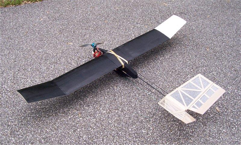
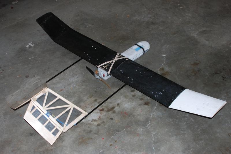
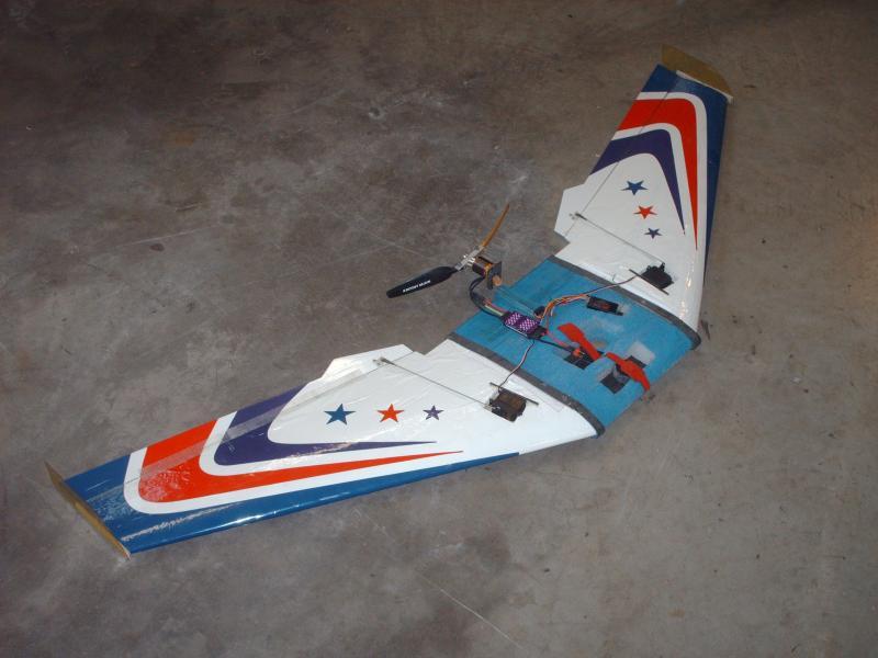
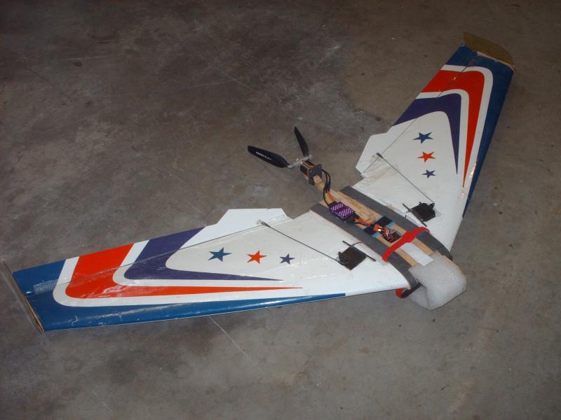
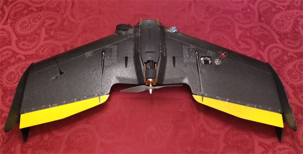
Nano Talon FPV - EPP foam fuselage. I bought the airframe at the Lebanon PA swap meet in 2019. Like the larger Talon which I bought in 2018, the Nano version had most of the electronics already in place. I added a receiver and FPV equipment, and cleaned up the linkage to the elerudders for sharper control, as the stock connections have a lot of slop. This planes flies very well, and comes apart into small pieces that easily fit into luggage to take on trips. It snaps together and can be assembled to fly in less than a minute. This plane is tiny and disappears quickly when flying line of sight, so it is a good thing it is made for FPV. Lemon 7ch DSMX stabilized receiver + Lemon satellite receiver, AKK X2 ultimate 5.8GHz video transmitter, LC filter, OSD for battery voltage, Runcam Split Mini, 30A ESC, five channels [ left elerudder (1 servo), right elerudder (1 servo), ailerons (1 servo), throttle (ESC), stabilizer on/off ] |
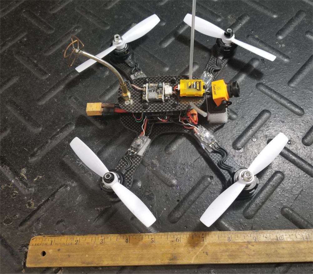 |
Quad-X 200 Quadcopter FPV Homemade carbon fiber frame, homemade power distribution board ZTW Spider Series 18A ESC 2-4S, with SimonK, no BEC (x4) - reflashed to latest BlHeli via Arduino USBLinker, configured BlHeli via BetaFlight FC pass-through Omnibus F4 flight controller Runcam Split 2, camera + HD DVR @ 1080P 60fps AKK X2P 800mW 5.8 video transmitter Racerstar 2205 2300kv motors (x4) Spektrum 4649T DSMX telemetry receiver LC filter - supplies clean power to FC + RC Rx + Runcam Split 2 + X2P video transmitter 7805 voltage regulator for FC + RC Rx |
 |
Quad-X 180 Quadcopter FPV Homemade 180 size carbon fiber frame LC filter - supplies power to FC + Runcam Split Mini + FX3 video transmitter Racerstar 1806 - 2280kv motors Spedix IS20A 4-in-1 20A ESCs - BlHeli-S, DShot 600 for control Omnibus F4 mini flight controller, built in BEC and OSD hardware Runcam Split Mini - camera + HD DVR @ 1080P 60fps AKK FX3 600mW 5.8GHz video transmitter Turbowing 5.8Ghz 8dBi RHCP mushroom antenna Spektrum 4649T DSMX telemetry receiver |
 |
Quad-X 130 Quadcopter FPV Hobbymate X130 carbon fiber frame Hobbymate 1306 motors Hobbymate 20A ESCs - BlHeli-S, DShot 600 for control Omnibus F4 Flight Controller with OSD & PDB Cyclops camera + DVR 600mW 5.8 GHz video transmitter Spektrum DSMX satellite receiver |
 |
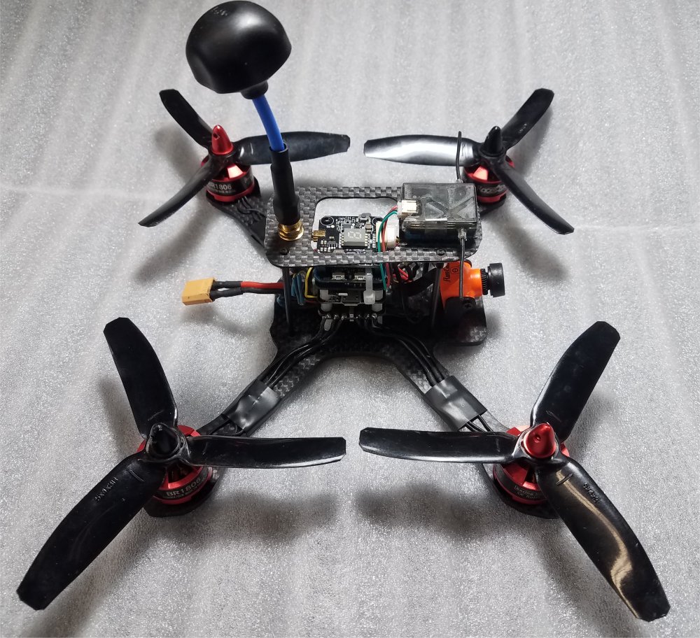
Hyperlow Quadcopter FPV with Caddx Orca 4K / GoPro Session 5 4K |
 |
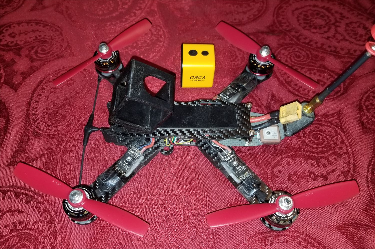
TBS Caipirinha Flying Wing FPV with Caddx Orca 4K / GoPro Session 5 4K |
  |
Hubsan Zino Pro+ Quadcopter with 3-axis stabilized gimbal 4K camera - on the left DJI Mavik Pro Platinum Quadcopter with 3-axis stabilized gimbal 4K camera - on the right |
|
Razor Flying Wing FPV with Caddx Orca 4K / GoPro Session 5 4K |
|
|
Reptile 800 Flying Wing FPV with GoPro Hero 4K |
|
 |
Video Downlink - First Person View (FPV) Cameras, on-board cameras w/ DVRs (CCD and CMOS) Video transmitters TV monitors and goggles |


